When talking about natural disasters, one question springs quickcly. Could be possible THAT disaster in our town, Santa Amalia, or in a place were we go on vacations? Let's try to answer these questions.
EARTHQUAKES.

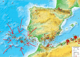
In Spain earthquakes are not so frequent. At least in our region. Earthquakes are produced when two tectonic plates collide with each other. If you look at the image on the right, all red points indicate locations where earthquakes have been produced. The worst area is the east of Andalusia and the strait of Gibraltar. However... I want you looking at the red circle, in the Atlantic ocean. On that area we have "San Vicente's tectonic fault": a place where two tectonic plates are colliding. This location is a "hot point", being able of producing catastrophic earthquakes; like the one which destroyed Lisbon in 1755. Spain was also affected by that earthquake: many towers, houses, churches and castles were damaged on that fatidic year. Experts consider that every 300 - 400 years S. Vicente's fault suffers a strong sismic event. So, do the math...
TSUNAMIS.
Because of all said before, you'll probably guess that Tsunamis can occur in our coasts. In the map of the right you can see the tsunamis we had in Spain in the last 500 years. In purple, the biggest one: the Lisbon tsunami, produced by Lisbon earthquake. That tsunami devastated Portuguese and Spanish coasts. A wave of 15 meters high stroke Huelva and Cádiz, killing 1200 people.
The most recent tsunami (2003) affected Balearic islands. A wave of 1 meter high arrived there, destroying some boats and small ships.
FLOODS.
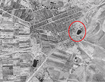
In Santa Amalia we know what a flood is. From time to time water spreads over the neighbourhoods of "La Mesta" and "Valdehornillos avenue". Why? Well, there is a very simple and evident explanation. This area, before, was a natural pool. Look at these two sky images. The first, from 1956, is an old one. You can see a dark stain surrounded by a red line. That was "La Mesta" pool: a shallow lake.
 |
| Santa Amalia's aerial view. 1956 |
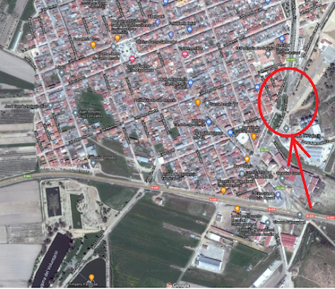
Look now at this second one. It is a satellite image. On it you can see that the old pool has been covered by houses and streets. What happened? Well, let's say that in the 60's the person in charge decided to drain the lake without studying the hidrography of the area. Nor draining system, neither proper sewers. An absolutely botch job. The consequence: when it rains a lot, the lake wants to recover its territory, raising up and flooding all the area.
 |
| Actual satellite image. |
FOREST FIRES.
 |
| San Isidro's hill satellite image. |
Every few years we also have a forest fire here, in Santa Amalia. Concretely in our only local natural space: San Isidro's hill. On the picture at the right you can see the area which always burns: the south east slope. The causes have been varied: imprudences, intentional fires, lightning storms... The thing is that, from time to time, some more holm oak trees die because of the fire. Climatic change does not help: every year summers are hotter and dryer; and winters usually don't bring enough water.
